

Los Alamos National Laboratory
Located in Los Alamos, New Mexico, Los Alamos National Laboratory holds a significant place in history as the birthplace of the Manhattan Project during World War II. The lab played a pivotal role in the development of the first atomic bombs, which were used in the bombings of Hiroshima and Nagasaki in 1945.
In 1942, during the early stages of World War II, the U.S. government established the Manhattan Project, a top-secret research and development initiative aimed at building atomic weapons. Los Alamos was chosen as the primary site for this ambitious endeavor due to its remote location and suitable geography, making it an ideal place for conducting highly classified research and testing.
Under the leadership of physicist J. Robert Oppenheimer, a team of brilliant scientists and engineers worked tirelessly at Los Alamos to design and assemble the world's first nuclear weapons. The laboratory was cloaked in utmost secrecy, and its existence was kept hidden from the general public throughout the war.
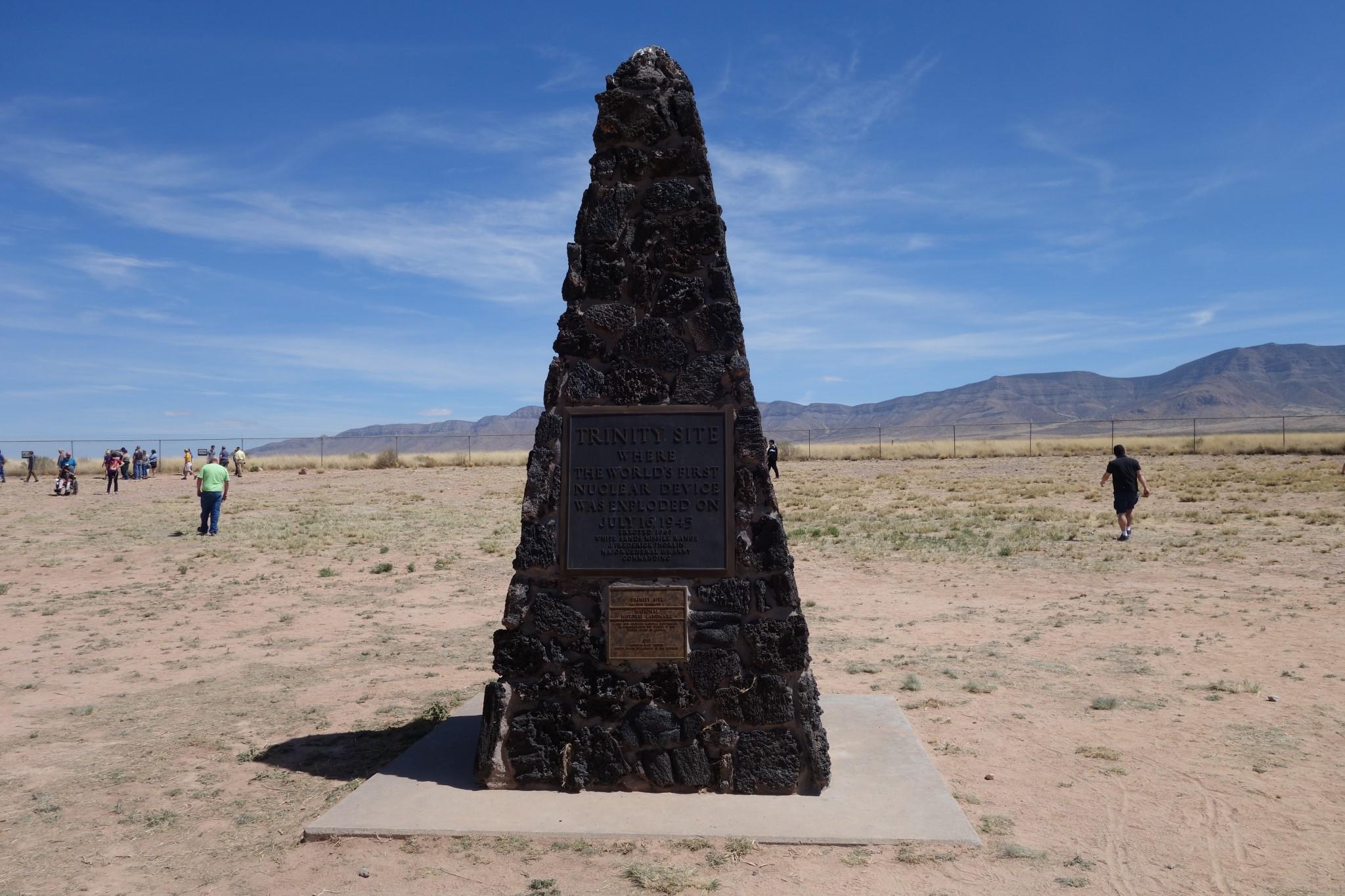
Trinity Test - July 16, 1945
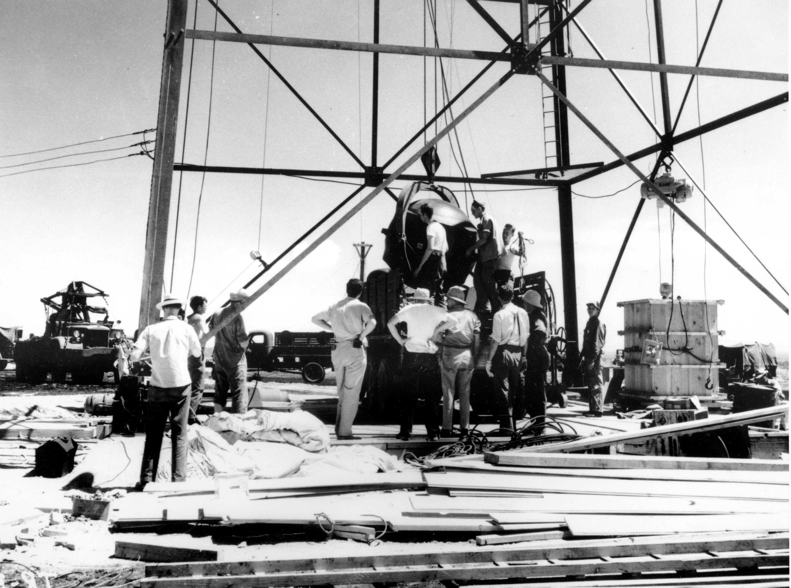
On July 16, 1945, the first successful test of an atomic bomb, code-named "Trinity," took place at the Alamogordo Bombing and Gunnery Range in New Mexico, not far from Los Alamos. The successful detonation of the plutonium implosion-type device confirmed the feasibility of the atomic bomb and paved the way for its eventual use in combat.
Following the successful Trinity test, the atomic bombs were deployed against Japan, leading to the bombings of Hiroshima on August 6, 1945, and Nagasaki on August 9, 1945. These catastrophic events led to Japan's surrender and marked the end of World War II.
Continued Contributions
After the war, Los Alamos continued its role as a premier research institution for nuclear science, national security, and non-proliferation efforts. The laboratory's research expanded into various scientific disciplines, including nuclear physics, weapons design, space exploration, and computational science.
In modern times, Los Alamos National Laboratory remains one of the United States' key facilities for nuclear research and development, but its focus has diversified to include a wide range of scientific and national security endeavors. The lab's expertise extends beyond nuclear weapons, encompassing fields such as materials science, high-performance computing, cybersecurity, and renewable energy technologies.
While Los Alamos National Laboratory holds a significant historical legacy as the birthplace of the atomic bomb, it continues to be at the forefront of scientific innovation and research, making crucial contributions to national security and global scientific advancements.
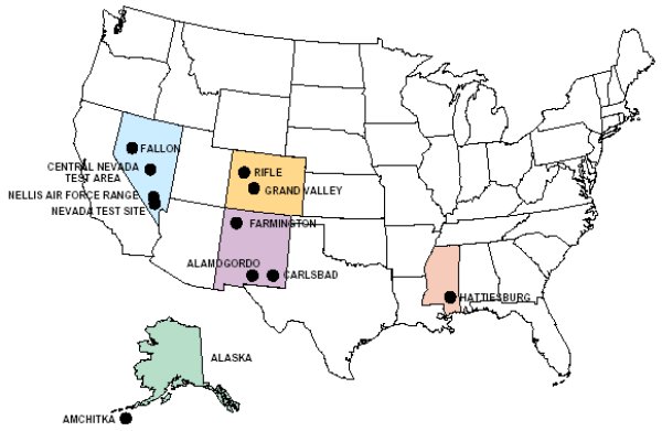
Hattiesburg, MS - A Hidden Radiation Threat
Hattiesburg, Mississippi, might not appear synonymous with nuclear testing, yet its link to such endeavors stretches back to the early 1960s. The covert "Project Dribble" saw the dispersal of low-level radioactive particles over the city, intending to study atmospheric nuclear material dispersion. Over the years, concerns have arisen about potential health impacts from this experiment.
The lingering radiation in Hattiesburg has been a subject of speculation, with locals raising questions about its long-term effects on the population. Though authorities have conducted surveys to assess radiation levels, the clandestine nature of "Project Dribble" has shrouded the full extent of radiation exposure in mystery. As health concerns persist, there is a growing call for comprehensive monitoring and investigations to ensure public safety.
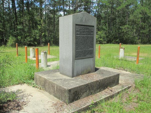
The Enigmatic Salmon Site in Baxterville, Mississippi
In the heart of Mississippi's dense forests, the Salmon Site in Baxterville stands as a lesser-known relic of the United States' nuclear testing era. Situated approximately 25 miles southwest of Hattiesburg, this remote area played a role in testing nuclear devices during the Cold War.
Thank you for providing more information about the Salmon Site in Baxterville, Mississippi. Based on the details you provided, here's a summary of the key points:
Location and Purpose:
The Salmon Site was located in Baxterville, Mississippi, which is situated fewer than 100 miles northeast of New Orleans. It was selected by the U.S. Atomic Energy Commission due to its geographical feature of sitting atop the Tatum Salt Dome, a large underground salt formation.
Nuclear Tests Conducted:
The site was used for nuclear testing, and two significant tests were conducted:
- The 5.3-kiloton Salmon explosion in October 1964: This test involved detonating a nuclear device 2,700 feet underground, creating a cavity in the salt dome. The bomb used in this test was approximately one-third the size of the atomic bomb dropped on Hiroshima in 1945.
- The 0.38-kiloton Sterling test in December 1966: This test involved setting off a smaller nuclear device inside the cavity created by the Salmon explosion. The purpose of this test was to assess the effectiveness of concealing a bomb test from sensors set up by arms control treaties. The results demonstrated that the technique could not fully conceal a nuclear test.
Current Status:
In 2010, the U.S. government transferred the land to the state of Mississippi. The state has since used the site as a state timber preserve. Today, the only standing evidence of the clandestine nuclear operation is a marker and plaque, serving as a reminder of the historical significance of the site.
Farmington, New Mexico - Project Gasbuggy
On December 10, 1967, the U.S. Atomic Energy Commission (AEC), a predecessor agency of the U.S. Department of Energy (DOE), detonated a 29-kiloton-yield nuclear device in the emplacement well (GB-E) at a depth of 4,227 feet in an attempt to stimulate production of natural gas from the overlying gas-bearing Pictured Cliffs Formation. The detonation produced extremely high temperatures that vaporized a volume of rock, temporarily creating a cavity surrounded by a fractured area extending outward from the detonation point. Shortly after the detonation, the overlying fractured rock collapsed into the void space, creating a rubble-filled collapse chimney that extends above the detonation point. As the former cavity cooled, the melted and vaporized rock collected and solidified at the bottom of the former cavity (now the lower part of the collapse chimney). Most of the high-melting-point radionuclides were trapped in this solidified melt rock, which is often referred to as melt glass due to its (glassy) texture.
The purpose of the detonation was to stimulate the flow of natural gas through the fractures created by the blast and use the collapse chimney as a collection chamber. This was the first natural gas reservoir stimulation experiment in the Plowshare Program, which was designed to develop peaceful uses for nuclear energy. AEC, the U.S. Department of the Interior, and the El Paso Natural Gas Company jointly sponsored Project Gasbuggy.
A reentry well (GB-ER) was drilled into the collapse chimney created by the detonation, and contaminated gas in the detonation zone (former cavity and collapse chimney) was produced and flared through a series of production tests. Production testing began in July 1968 and ended in October 1969 after producing 213 million cubic feet of natural gas during five tests. The test stimulated gas production in greater quantities than in nearby conventional gas wells, but the natural gas still had measurable amounts of radioactive constituents. Results of the natural gas production testing were evaluated, and it was determined that the gas had a significantly lower heat value and that fracturing into the gas-bearing formation outward from the chimney (above the cavity) did not penetrate as extensively as expected. In 1976, it was decided that no further testing would be conducted at the site.
AEC decommissioned and demobilized the site in 1978. Structures and equipment used for the test were decontaminated, if necessary, and removed. Liquid radioactive waste was injected into the former cavity, now the lower part of the collapse chimney. Solid radioactive waste was removed and transported to the Nevada National Security Site (formerly known as the Nevada Test Site), and test wells were decommissioned and plugged. Soil sampling was performed in 1978, 1986, 2000, and 2002. Cultural resources, endangered and sensitive species, and floodplain and wetland surveys were performed in 1993. Final surface remediation was completed in 2004.
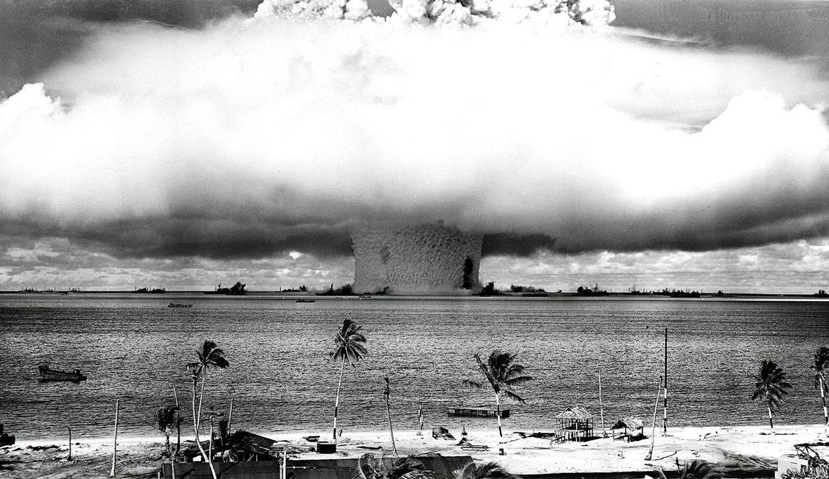
Marshall Islands Nuclear Tests
The Marshall Islands Nuclear Tests refer to a series of nuclear tests conducted by the United States in the Marshall Islands, a group of islands located in the central Pacific Ocean. These tests were carried out as part of the United States' nuclear weapons testing program during the mid-20th century, primarily during the Cold War era.
The Marshall Islands, which were then administered by the United States as part of the Trust Territory of the Pacific Islands, were chosen as a test site due to their strategic location and relatively low population. The testing took place at two primary atolls in the Marshall Islands: Bikini Atoll and Enewetak Atoll.
Bikini Atoll Tests
- Operation Crossroads (1946): The first post-World War II nuclear tests were conducted at Bikini Atoll. The tests were designed to study the effects of nuclear explosions on ships and equipment. Two atomic bombs were detonated: "Able" and "Baker."
Enewetak Atoll Tests
- Operation Greenhouse (1951): The first thermonuclear test, codenamed "George," was conducted at Enewetak Atoll. It involved the use of a boosted fission bomb and paved the way for the development of more powerful thermonuclear weapons.
- Operation Ivy (1952): This series included two tests at Enewetak Atoll. The first test, codenamed "Mike," was the first successful test of a full-scale thermonuclear device. The second test, "King," involved the use of a dry fuel hydrogen bomb.
- Operation Castle (1954): This series included several tests, with the most notable being the "Bravo" test. The "Bravo" test, a thermonuclear device, was the most powerful nuclear explosion ever conducted by the United States. It had an unexpectedly large yield, causing significant radioactive fallout and contamination on nearby islands and ships.
- Operation Redwing (1956): This series included multiple tests, including thermonuclear devices and "dirty" bomb tests. The tests were aimed at developing smaller, more deliverable nuclear warheads.
- Operation Hardtack I (1958): This series included several high-altitude tests and underground tests at Enewetak Atoll. The high-altitude tests were part of efforts to study the effects of nuclear explosions on space communications and long-range radar.
- Operation Dominic I and II (1962): These were a series of tests conducted in response to the Soviet Union's resumption of atmospheric nuclear testing. The tests included high-altitude detonations and missile defense tests.
The nuclear tests conducted in the Marshall Islands had significant environmental and health consequences for the local populations and the surrounding ecosystems. The inhabitants of Bikini and Enewetak Atolls were relocated to other islands in the Marshall Islands due to the contamination caused by the tests. The legacy of the nuclear testing continues to impact the Marshall Islands, with ongoing efforts to address environmental remediation and compensate affected communities.
It's important to note that the Marshall Islands is an independent nation today, and it has advocated for nuclear disarmament and the recognition of the lasting effects of the nuclear tests conducted in its territory on the international stage.

Project Shoal Site
On October 26, 1963, a 12-kiloton nuclear device was detonated here in granite some 1,211 feet below the ground surface. The Project Shoal site was located about 30 miles east of Fallon, Nevada. The goal was to test underground nuclear detonations, as atmospheric tests were forbidden by the Limited Test Ban Treaty during the Cold War. The site's granite bedrock made it a suitable location for this type of test.
Project Shoal was heavily monitored, particularly for tritium (hydrogen-3), a radioactive isotope of hydrogen. Tritium was of interest because it could contaminate water, which was crucial to monitor in the arid lands where the test was conducted. The site continues to be subject to ongoing surveillance and research due to potential environmental impacts.
If you want to visit the Project Shoal site, go about 31.9 miles east on US-50 from the intersection of US-50 and US-95 N in Fallon, Nevada, to the junction of Nevada SR 839 (the "Scheelite Mine Rd"). Proceed 5 miles south to GZ ("ground zero"; "G2" on some maps due to a cartographer's misreading) road and turn right. The road is graded and should be passable to ordinary passenger cars in dry weather. The stone monument is about 250 feet up the access road, and visitors can drive right up to it.
Other Nevada Nuclear Test Sites
In the early 1960s, atmospheric nuclear tests were banned by the Limited Test Ban Treaty, leading the U.S. Government to shift focus to underground testing. Nevada became a key location for these underground tests.
Other significant nuclear test sites in Nevada include the Nevada Test Site (now known as the Nevada National Security Site), which hosted numerous underground and atmospheric tests. The Nevada Test Site was essential for nuclear weapons testing during the Cold War.

Additionally, there were various other remote test sites across Nevada, contributing to the understanding of nuclear explosives and their effects.